Data Downloading, Interoperability, and Working with Projections in Python
Sand Mining Suitability Project

Goals
Technical Goals
- Familiarization with data downloading from a variety of internet sources
- Prepare data and importing it to ArcGIS
- Join data and building a geodatabase
- Projecting data
- Write a technical report about data sources and accuracy
To demonstrate the technical goals, I will be building a sutiability and risk model for sand mining in western Wisconsin with Trempealeau County and a few other western Wisconsin counties as the area of interest. For this portion of the multi-lab project I:
- Downloaded and prepared relevant data
- Wrote a technical report about the data sources and accuracy
- Produced four maps
- County Location
- County Elevation
- County Land Cover
- County Agriculture Crop Type
General Methods
A variety of base data was collected for this project from a variety of online sources. Data sets and their descriptions are listed in the table below. For each set I went to the source website (hyperlinked in the source column), downloaded, unzipped, and saved each file. Additional data preparation is described in the Necessary Preparation column. After all files have been properly prepared, they were added to the Trempealeau County geodatabase
Base
Data Set
|
Description
|
Source
|
Necessary
Preparation
|
US Railway Network Shapefile
|
Shapefile of US railways
|
Clip data to Trempealeau County, change to
Trempealeau County’s Projection
|
|
National Land Cover Raster and Digital Elevation Models
(DEM) for Trempealeau County
|
Raster of US land cover types and DEMs for Trempealeau County and
surrounding area
|
Used Mosaic to New Raster tool to combine the two DEMs.
*Raster
|
|
Wisconsin Crop Cover Raster
|
Raster describing the types of crop cover across
Wisconsin
|
*Raster
|
|
Trempealeau County Land Records Geodatabase
|
Geodatabase containing a variety of datasets for Trempealeau County including
Boundaries, Cadastral, Emergency, Land Use, Recreation, and Transportation shapefiles
|
||
US Web Soil Survey
|
Raster describing soil types across the United
States
|
Imported tabular text files to geodatabase schema.
*Raster
|
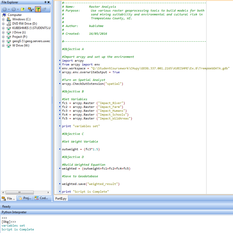
*Check out my Python Scripts post Script 1 which describes how rasters were prepared to import to the geodatabase.
Data Accuracy
|
Base Data Set
|
Scale
|
Effective Resolution
|
Minimum Mapping Unit
|
Planimetric Coordinate
Accuracy
|
Lineage
|
Temporal Accuracy
|
Attribute Accuracy
|
|
US Railway Network
Shapefile
|
1:24,000 to 1:100,000
|
NA
|
NA
|
NA
|
Official Railway Guide,
State DOTs, Rail companies, FRA’s Automated Geometry Locations
|
6/19/2015
|
NA
|
|
National Land Cover Raster
|
1:100,000
|
30m
|
5 pixels
|
25m
|
Multi Resolution Land
Characteristics
|
04/09/2004 to
11/11/2011
|
Not yet conducted
|
|
DEMs for Trempealeau
County
|
1:24,000
|
10m
|
NA
|
NA
|
US. Geological Survey
|
4/10/2015
|
NA
|
|
Wisconsin Crop Cover
Raster
|
1:100,000
|
30m
|
5 pixels
|
25m
|
USDA/NRCS/NASS
|
2002 to 2016
|
All attributes:
accuracy between 85% and 95%
|
|
US Web Soil Survey
|
1:12,000 to 1:63,360
|
NA
|
3 acres
|
0.01in
|
USDA Soil Conservation
Service (1977)
National Resources
Conservation
|
2004
|
All attributes tested
against standard tables of valid soil attributes.
|